America's Auction Channel
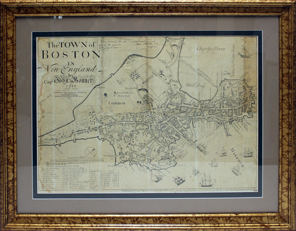
THE TOWN OF BOSTON Antique 1835 Reissue of 1722 Map
THE TOWN OF BOSTON Antique 1835 Reissue of 1722 Map
Couldn't load pickup availability
This is an antique map titled "The Town of Boston in New England". This is a 1835 facsimile of the map by created by John Bonner which was originally engraved and printed by Francis Dewing in 1722 [i.e.1725].
In 1835, George Girdler Smith (1795-1878), an engraver, re-issued the 1722 Bonner map of Boston. The facsimile map, based on the Bonner map in the collections of the Massachusetts Historical Society (the third state of the map probably printed in 1725), includes the following note of authenticity by Stephen P. Fuller, a surveyor, "I have examined this plan and find it to be an exact copy of the original."
Captain John Bonner was a navigator and shipwright. His map map is the first surviving printed map of Boston and the first town plan printed in what is now the United States. It shows the configuration of Boston as it was for almost the first 200 years of its existence. The map features a legend with points of interest located throughout the town.
The map displays wear due to age including folds, pinholes, and evidence of exposure to moisture. The framed dimensions are 27.5"h x 33.5"w.
Materials
Materials
Shipping & Returns
Shipping & Returns
Dimensions
Dimensions
Care Instructions
Care Instructions